
Path through the forest: 5 navigators for tourists

We independently test the products and technologies that we recommend.
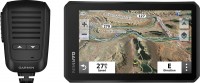
 Price from 6 005 up to 6 006 ₴ |
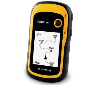
Garmin eTrex 10 Price from 6 005 up to 6 006 ₴ → One of the most affordable tourist models, which can serve as a good solution if you decide to buy a GPS navigator for relatively infrequent and not too far hikes. Thanks to its rounded shape and rubberized body, it is convenient to hold in your hand. The device can also be used when riding a bicycle / moto / ATV, if you purchase a separate holder for attaching a GPS navigator to the steering wheel. For rock climbers, there is a mount with a carabiner on the market. The operating time from two removable AA batteries is up to 25 hours, which greatly distinguishes a tourist navigator from a car one. Shockproof and waterproof housing will withstand any weather conditions while traveling. A monochrome display is already a rarity in modern gadgets, but it is on it that the image is best seen in bright sunlight. The control is carried out using rubberized side buttons and a joystick. eTgeh 10 has only 8 GB of built-in memory with base cards from all over the world. The possibility of downloading additional maps is not provided. According to user reviews, it is very easy to create routes and save waypoints, even if you are using such a device for the first time. The USB port provides the ability to connect to a computer to download geocaching caches (a special tourist game, the essence of which is to find caches hidden by other participants). To increase the accuracy of determining your location on the map, you can enable the definition of GPS and GLONASS satellites in the menu at the same time. Additionally, eTgeh 10 has a compass, a calendar, a stopwatch and a travel computer that stores information about the speed and time of the completed or remaining route. As for similar models, we will highlight Garmin Dakota 10 and Garmin eTrex 20 , which boast colour touch displays and the ability to download additional maps. |
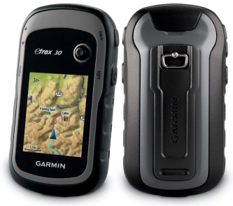 |
The senior model in the Garmin eTrex series. It already has a 2.2-inch colour display. The case is shockproof rubberized with a water protection level of IPX7 (at a depth of up to 1 metre under water can be less than half an hour). Rubberized control buttons are located on the sides of the grey case, and a joystick is located above the display to control the thumb of the right hand. It is quite convenient to use the device. The only thing that needs to be noted is that in the car profile, entering the address search is still faster on the touch screen. But this device can be used with gloves, unlike touch navigators. Basic topographic maps and road maps from Aeroscan or Navionics are loaded onto the built-in memory of 1.7 GB (depending on the region). And also this model supports additional maps (tourist, road, sea), as well as satellite images that can be downloaded to a micro-SD memory card, the memory card slot is securely hidden in a waterproof battery compartment. Continuous operation time — up to 25 hours from two batteries or AA batteries (purchased separately). The built-in electronic 3-axis compass will help you find the azimuth at any (non-horizontal) position of the GPS device. In this device, the function of an altimeter is performed by a barometric altimeter. It also registers in the form of graphs any changes in atmospheric pressure over a given time. For more accurate positioning, in addition to GPS satellites, Garmin eTrex 30 is able to simultaneously detect GLONASS satellites. After the power is turned off, the process of finding satellites is carried out very quickly, thanks to the built-in HotFix system that predicts the location of satellites. Using wireless communication, you can send route data, geocaching caches and waypoints to another Garmin navigator that supports this wireless function. Garmin eTrex 20 has similar functions, it lacks only a barometric altimeter and wireless communication between devices. |
 |
The shape of the case resembles an old mobile phone with control buttons located under the display and an antenna protruding from the case. But despite this, Garmin GPSMAP 62s is one of the most popular models of navigators among tourists. This device is rubberized, shockproof, moisture resistance level IPX7. The temperature range of use is from -15 to +70 degrees. The 2.6-inch colour screen has a display brightness adjustment, rubberized control buttons are also illuminated in the dark. On the back side of the case, under a powerful moisture-proof plug, there is a USB 2.0 connector for connecting to a computer and an antenna connector for connecting an external GPS antenna. The model is equipped with a carbine, and it is also possible to purchase separately mounts on the handlebars of a bicycle, motorcycle or ATV. The time of continuous operation of the navigator is stated to be up to 20 hours from two "finger" AA batteries. Garmin recommends using nickel-metal hydride or lithium batteries. The battery compartment is reliably protected from water, so there is a slot for a micro SD memory card on which you can download more detailed maps and satellite images. On the built-in memory of 1.7 Mb there are preloaded road maps for Ukraine Navlux or Aeroscan, and for the Russian Federation – TOPO road maps. Garmin GPSMAP 62s can remember up to 2K waypoints, 200 completed route tracks and up to 200 future routes. The 3-axis electronic compass (which works correctly not only in one horizontal axis) has a function for sailors to detect directions or "take a bearing" (movement on the object). The barometric altimeter records changes in altitude and atmospheric pressure. And also this model has a number of additional functions: geocaching is a game for treasure hunters of caches based on GPS coordinates posted on the Internet by other participants of the game who created the cache; data exchange with another Garmin navigator wirelessly at a distance not exceeding 3 metres; calendar for hunting and fishing, showing sunrise/sunset and data on the phases of the moon; forecast of the optimal time for fishing; stopwatch, calculator, alarm clock. Similar models Garmin GPSMAP 64 and Garmin GPSMAP 64ST are also able to work with the GLONASS system. |
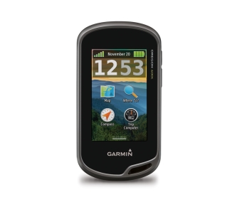 |
The latest model in our today's selection of the best GPS navigators, which is more similar in body shape to a tourist one. In fact, the device is universal, because the functionality allows you to use it for sea and hiking trips, for hunting and fishing, for training on a bicycle and for auto navigation on highways. All models of the Oregon series see American (GPS) and Russian (GLONASS) satellites and are supplied complete with a carbine. The ending "t" in the name of the Oregon 600t/650t models indicates a complete set of topographic maps of Europe, and the models Garmin Oregon 650 and Garmin Oregon 650t additionally, there is a built-in camera with a flash. The 3-inch touchscreen (400x240) distinguishes the Oregon 600t from other tourist models. There are also side buttons here, but there are only two of them — on/off and assignable. Horizontal/landscape orientation of the screen is provided. For use in the car, there is an audio notification about turns when driving along the route, a 3D map mode, as well as the ability to work from a car cigarette lighter (cable is purchased separately). Users note that even when exposed to direct sunlight, information from the travel computer and data from the heart rate sensor are visible on the screen, which should interest runners. For cyclists, there is information from a sensor that tracks the speed of pedaling per minute. One battery charge lasts up to 16 hours. If this is usually a lot for athletes, then hunters and fishermen can still be recommended to take a set of spare batteries with them. The Oregon 600t is equipped with a barometric altimeter, a three-axis electronic compass, a calendar for hunting/fishing, a table of sunrises, sunsets, tides and special functions for geocaching. Supports wireless data transmission (waypoints, tracks, routes and geocaching caches) via Bluetooth. The microSD card slot makes it possible to install additional cards, for example, BirdsEye satellite images and detailed BlueChart g2 and Unity Navigator maps. |
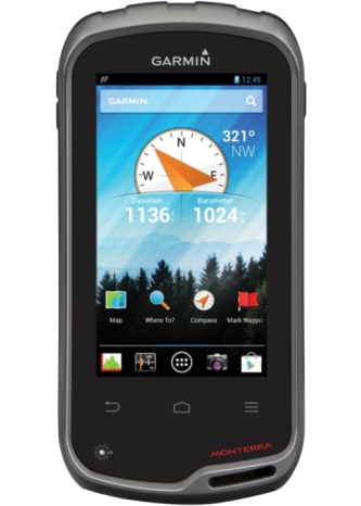 |
The top model from Garmin and so far the only one on the Android 4.0.4 operating system. with full support for applications from the Google Play store, including third-party navigation programs. We will not compare this model with a smartphone, because it is primarily a navigation device, although with the capabilities of a smartphone (except GSM). As for a universal navigator, the Monterra has the largest 4-inch touchscreen under a durable anti-reflective mineral glass. Shockproof and waterproof housing with a level of protection like all Harmines. An 8-megapixel camera with a flash will allow you to take photos and shoot videos (with GPS coordinates) in very good quality as for a portable device. Of the entertainment functions, this device also has a radio that can be listened to through the headphone output. The 3.5 mm jack is closed from water ingress with a rubber plug. This navigator supports wireless communications: Bluetooth, Wi-Fi, NFC, and ANT+ (synchronization of air temperature data). The special functions of the navigator on the display look like application icons (familiar to Android users), and there are also basic or downloaded Android OS applications on another desktop field. On the built-in memory of 6 GB, the Navlux road maps of Ukraine or the TOPO road maps of Russia have been reloaded, and Monterra can also be equipped with topographic maps of Europe TOPO. Supports expansion with additional micro SD cards up to 64 GB, which is located, as in all universal models, in the battery water-insulated compartment. Garmin Monterra is equipped with a lithium-ion battery, which allows you to use the device for up to 16 hours, and then you can change the flat battery to three "finger" AA batteries and use the navigator for another 22 hours. To use this device in the car there is a landscape orientation of the screen, 3D map mode. Voice notification and charging via a car mount, purchased separately. Garmin Monterra is equipped with a full set of universal functions:
|


Articles, reviews, useful tips
All materials

