Усе про навігацію у смартфоні: GPS, Beidou, Galileo та інші

Ми незалежно перевіряємо товари та технології, які рекомендуємо.

У світі існує кілька глобальних систем супутникової навігації, які гармонійно доповнюють одна одну: американська GPS, російська ГЛОНАСС, європейська Galileo та китайська Beidou. Влаштовані глобальні навігаційні системи за одним схожим принципом. Вони об'єднують комплекси наземного та космічного обладнання для позиціонування у просторі та часі, на підставі чого здійснюється визначення місцезнаходження, швидкості, напрямку та інших параметрів руху об'єкта.
1. Базові принципи роботи
Принцип роботи систем навігації зав'язаний на вимірюванні відстані від супутників на орбіті, місцезнаходження яких достовірно відомо з великою точністю, до антени приймаючого пристрою. Кожен супутник випромінює сигнали точного часу, використовуючи атомні годинники, синхронізовані з системним часом. Під час прийому сигналу від орбітальних супутників обчислюється затримка між часом випромінювання сигналу та часом його прийому антеною кінцевого пристрою. За цією інформацією приймач обчислює координати антени. Переміщення об'єкта обчислюються на основі вимірювання часу, витраченого на переміщення між двома або більше точками з визначеними за попередніми обчисленнями координатами.
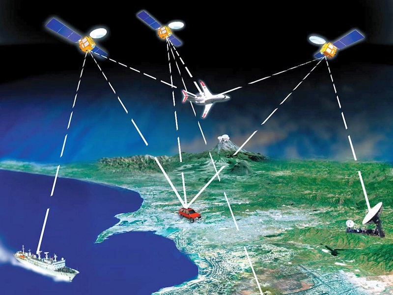
Для точного позиціонування у просторі антена приймача повинна отримувати сигнал хоча б від трьох супутників одночасно, а краще — від чотирьох. Тріо супутників передають дані про своє місцезнаходження відносно Землі та один одного, четвертий — фіксує час проходження сигналу від передавача до приймача. Оскільки супутники весь час перебувають у русі, їхню траєкторію відстежують наземні станції. Актуальна інформація надсилається на гаджети в альманахах — бібліотеках з найточнішими відомостями про місцезнаходження всіх доступних супутників. Оновлюються альманахи через мобільні мережі або по Wi-Fi, що в рази скорочує тривалість «холодного старту» систем навігації.
Первинно супутникові системи навігації були військовими розробками. Під контролем військових відомств багато з них залишаються і досі. Першою загальнодоступною навігаційною системою стала американська GPS. Власне, слова «навігація» та «GPS» довго сприймалися як синоніми.
2. GPS
Розробкою проекту NAVSTAR (Navigation Satellite Time and Ranging) зайнялося Міністерство оборони США у 70-х роках минулого століття. Перший супутник системи запустили на орбіту у 1974 році, а за наступні 20 років у космос вивели всю необхідну кількість супутників для коректної роботи системи (24 шт.). Навігаційну систему GPS (The Global Positioning System) відкрили для цивільних потреб, однак, щоб уникнути її військового застосування противниками, точність системи примусово зменшили спеціальними алгоритмами приблизно до 100 м. Більшу частину обмежень зняли лише на початку третього тисячоліття. Система навігації GPS складається з 32 супутників, які обертаються навколо Землі по кругових орбітах у шести різних площинах. Усі супутники розташовані на орбіті добової кратності — 20200 км над рівнем моря. Як результат, у будь-якій точці планети завжди спостерігається не менше чотирьох супутників у будь-який момент часу (зазвичай одночасно видно від 4 до 12 супутників). Кожні 30 секунд супутник передає радіосигнали на частоті 1575.42 МГц, у яких містяться відомості про положення супутника у просторі, інформація про якість сигналу, похибка супутникових годинників та коефіцієнти моделі іоносфери.

на орбіті добової кратності — 20200 км над рівнем моря.
Підвищити точність визначення координат покликані наземні станції, які передають поправки для диференціального режиму: WAAS на території США та Канади, EGNOS — у європейських країнах. Стандартні приймачі фіксують місцезнаходження з точністю у кілька метрів, новітні мають точність до кількох сантиметрів.
Ранні версії GPS мали довгий час так званого «холодного старту». Це обумовлювалося необхідністю передачі на приймальний пристрій альманаху (астрономічного календаря) та цілого вороху супутніх коригувань. Проблему вирішила допоміжна система aGPS (Assisted GPS). Пристрої з нею можуть отримувати службову інформацію від найближчої базової станції оператора стільникового зв'язку, що позбавляє гаджети від необхідності підтримання прямого зв'язку з супутниками і в кілька разів зменшує час запуску навігації (буквально за кілька секунд).


3. Dual GPS
Для підвищення точності визначення місцезнаходження у сучасних модулях навігації зустрічається технологія Dual GPS. Приймачі з її підтримкою працюють не на одній частоті, як традиційні аналоги, а на двох (L1 + L5 — 1575 МГц + 1176 МГц). Подібний формат помітно підвищує точність позиціонування — в окремих випадках до 10 – 20 см. Dual GPS дозволяє коректно обробляти сигнали, відбиті від висотних будівель в умовах щільної міської забудови. До того ж діапазон L5 має високу пропускну здатність і швидкість передачі, тому кількість шуму та перешкод значно скорочується.

Зазначимо, що повноцінна підтримка L5 є в європейській системі Galileo та японській QZSS (детальніше про них розказано нижче). У GPS таке мовлення здійснює лише половина супутників, а в системі ГЛОНАСС воно очікується і зовсім не раніше 2030 року.


4. ГЛОНАСС
Російську радіонавігаційну супутникову систему ГЛОНАСС почали розробляти ще за СРСР у 1970-х роках. Льотні випробування системи стартували у 1982 році з запуском на орбіту першого супутника. Повну групування з 24 супутників вдалося розгорнути ближче до 1995 року. Однак через проблеми з фінансуванням та коротким експлуатаційним ресурсом космічних апаратів вже до 2001 року число працюючих супутників скоротилося до шести. Ситуацію вдалося переломити в середині «нульових», а про завершення створення системи навігації ГЛОНАСС оголосили під завісу 2015 року. Її основою є 24 активних супутники, які обертаються на середній висоті 19100 км над поверхнею Землі у трьох орбітальних площинах. По кожній орбіті рухаються 8 рівномірно розподілених супутників. Також у системі ГЛОНАСС передбачені резервні космічні апарати.
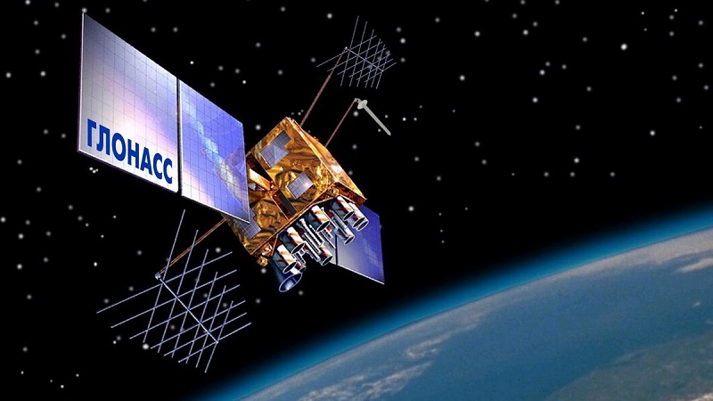
Супутники системи передають радіовипромінювання двох типів: навігаційний сигнал діапазону L1 та навігаційний сигнал високої точності у діапазонах L2 та L3. Похибки при визначенні місцезнаходження становлять близько 3-6 м, а з коригуваннями — до 1 м. Важливою особливістю ГЛОНАСС є можливість застосування навігаційної системи на високих широтах у північних та південних полярних регіонах, де сигнал GPS ловить погано.
5. Galileo
Galileo — європейська супутникова система навігації, створена як альтернатива американській GPS та російській ГЛОНАСС. Примітно, що вона знаходиться під контролем цивільних відомств. При повній флотилії з 24 активних супутників система дає точність до 1 м у публічному режимі та до 20 см з сервісом GHA. Всього ж на орбіті знаходяться 30 супутників системи Galileo (6 космічних апаратів перебувають у гарячому резерві).
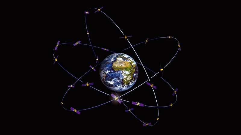
Супутники Galileo обертаються у трьох орбітальних площинах на висоті 23222 км над поверхнею планети. На кожній з орбіт при повному розгортанні системи знаходиться по 8 діючих та 2 резервних супутники. Ця конфігурація групування забезпечує одночасну видимість з будь-якої точки земної кулі щонайменше чотирьох апаратів. У перспективі супутники системи Galileo зможуть передавати сигнали тривоги користувачів у регіональні рятувально-координаційні центри. При цьому буде передбачено зворотний зв'язок — підтвердження отримання повідомлень про тривожні ситуації.
6. Beidou
У 2020 році створення глобального покриття завершилося для китайської навігаційної системи Beidou. Її супутникова флотилія налічує 48 космічних апаратів, у роботі знаходяться 35 супутників. Розміщуються супутники на трьох орбітах: середній круговій, геостаціонарній, геосинхронній нахиленій високій.
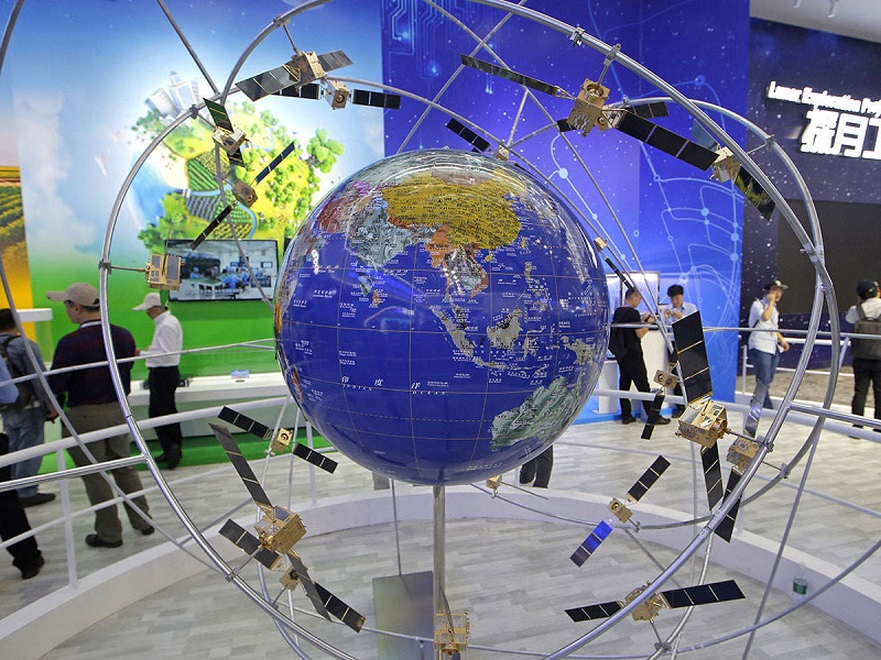
Прагнення Піднебесної до створення власної супутникової навігаційної системи обумовлено бажанням здобути незалежність від США та її системи GPS. Точність позиціонування Beidou для цивільного населення становить менше 10 метрів, а точність вимірювання швидкості досягає близько 0.2 метра за секунду.
7. Інші регіональні системи
Окремі країни розвивають власні системи навігації. На глобальний рівень вони поки лише виходять, однак як регіональні навігаційні системи вже повсюдно працюють IRNSS (Indian Regional Navigation Satellite System) в Індії, а також QZSS (Quazi-Zenith Satellite System) в Японії та країнах Азіатсько-Тихоокеанського регіону.
8. GNSS
GNSS — це абревіатура від Global Navigation Satellite System (Глобальна супутникова система навігації). Приймачі Multi-GNSS можуть отримувати сигнали, передані кількома навігаційними системами одночасно: GPS, ГЛОНАСС, Galileo, Beidou, QZSS, IRNSS. Тим самим суттєво підвищується точність позиціонування за рахунок прийому більшої кількості сигналів від супутників.
Фактично під терміном GNSS мається на увазі сукупність усіх глобальних навігаційних систем геопозиціонування. І хоча кожна з них використовує свої кодування для передачі сигналів, приймачі GNSS здійснюють правильну інтерпретацію отриманої інформації в рамках одного пристрою.
9. Супутниковий зв'язок у смартфонах Apple
Окремо варто згадати супутниковий зв'язок у смартфонах Apple. Він служить для екстреної відправки повідомлень рятувальним службам поза зоною покриття мобільної мережі. Як навігаційна система такий зв'язок не застосовується. «Айфони» (від 14-ї моделі та новіше) вміють подавати сигнали лиха у місцеву службу екстреної допомоги. При цьому самостійно писати повідомлення не вийде — у смартфон первинно вшиті шаблони готових звернень. Апарат ловить зв'язок із супутником на відкритій місцевості. У який бік направити смартфон для кращого прийому сигналу — він підкаже сам. Після встановлення зв'язку телефон відправляє у службу порятунку геолокацію, деякі персональні дані (з медкарти у додатку «Здоров'я»), а також рівень заряду iPhone.
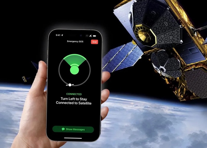
куди необхідно повернутися у просторі для впевненого прийому сигналу.
Первинно підтримку супутникового зв'язку впровадили лише у США та Канаді. Втім, вже зараз вона доступна майже по всьому світу. Не працює опція лише на пристроях, які придбані в Вірменії, білорусі, Гонконгу, Казахстані, Китаї, Киргизстані, Макао та росії. Для роботи системи екстреного зв'язку Apple розгорнула флотилію з 17-ти низькоорбітальних космічних апаратів, які були запущені супутниковим оператором GlobalStar. Під завісу 2024 року компанія Apple впровадила повноцінну підтримку обміну повідомленнями через космічний зв'язок (для цього знадобиться iPhone з iOS 18) та інвестувала на запуск нових супутників понад $1 млрд. З нарощуванням чисельності ескадри цілком можлива поява інших функцій, наприклад, дзвінків або доступу до інтернету з будь-якого куточка земної кулі. Загадувати поки рано, однак напевно подібні послуги будуть коштувати недешево.


10. Висновок
Працюючи спільно один з одним у єдиній синергії, різні навігаційні системи забезпечують більш точне вимірювання місцезнаходження, особливо у густонаселених районах та великих мегаполісах, де сигнал багаторазово відбивається від високих споруд. Сучасні гаджети часто підтримують роботу з усіма відомими супутниковими системами, завдяки чому навігація стає точнішою буквально день у день.


Статті, огляди, корисні поради
Усі матеріали