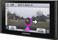
GPS-навігатор Garmin Nuvi 1690
 | Товар застарів 2 499 грн. Невеликий навігатор з можливістю виходу в Інтернет є доступ до пошуку Google. Є функція автоматичного прорахунку маршруту та його зміни у разі відхилення від нього. Найбільш популярні і часто використовувані маршрути можна зберегти в пам'яті приладу, всього до 100 шт. По мірі руху по маршруту цей навігатор буде активно допомагати водієві голосовими підказками. За потреби в пам'ять пристрою можна завантажити карти місцевості. |
Закрити
Рекомендуємо товари в наявностіGPS-навігатори Garmin →

Garmin Nuvi 1690
Тип:для легкових авто
Діагональ екрану:4.3 "
Роздільна здатність:480x272 пікс
Інтерфейси:Bluetooth
Час роботи:до 3 год
Невеликий навігатор з можливістю виходу в Інтернет є доступ до пошуку Google. Є функція автоматичного прорахунку маршруту та його зміни у разі відхилення від нього. Найбільш популярні і часто використовувані маршрути можна зберегти в пам'яті приладу, всього до 100 шт. По мірі руху по маршруту цей навігатор буде активно допомагати водієві голосовими підказками. За потреби в пам'ять пристрою можна завантажити карти місцевості.
Всі характеристики
Характеристики Nuvi 1690
|
| |||||||||||||||||||||||||||||||||||||||||||||||||||
Інформація в описі моделі носить довідковий характер.
Завжди перед покупкою уточнюйте у менеджера інтернет-магазину характеристики і комплектацію товару
Каталог Garmin 2025 - новинки, хіти продажів і найактуальніші моделі Garmin.
Завжди перед покупкою уточнюйте у менеджера інтернет-магазину характеристики і комплектацію товару
Каталог Garmin 2025 - новинки, хіти продажів і найактуальніші моделі Garmin.
Серія Garmin Nuvi (авто)Порівняти в таблиці →


для легкових авто, 5 ", пожизненное обновление карт, Lane Guidance, до 4 год роботи, 203 г
для легкових авто, 6 ", пожизненное обновление карт, Lane Guidance, відеореєстратор, камера, до 0.5 год роботи, 319 г

для легкових авто, 5 ", пожизненное обновление карт, Lane Guidance, до 4 год роботи, 203 г

для легкових авто, 5 ", пожизненное обновление карт, Lane Guidance, DAB, магнітне кріплення, до 4 год роботи, 192 г
Додаткові функції і можливості gps-навігатора Garmin Nuvi 1690:
- Можливість виходу в інтернет
- Автоматичний перерахунок маршруту (при відхиленні від курсу або обьезде)
- Піктограми автомобілів (вибір значка місцеположення на карті)
- Вибір критерію розрахунку маршруту (мінімальний час, мінімальна відстань, дороги)
- Фото навігація