
TOP 5: the best GPS-navigators

We independently test the products and technologies that we recommend.

The technical characteristics of each model from our review can be compared in this
Before we proceed directly to the review, it is worth paying attention to the following fact. If the task of all GPS devices is the same (to determine the location on the map), then the maps themselves installed in the navigators are different. And in fact, the high-quality operation of the device most often depends on the cards.
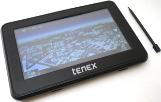 |
One of the most accessible navigators, which nevertheless handles perfectly with the function of route navigation and orientation on the map. First of all, it is intended for use in a car, as evidenced by the rectangular "flatbed" shape of the case, as well as the complete set: a holder with a suction cup for quick and easy installation on the windscreen and a charger for a twelve-volt cigarette lighter. For hiking, you can also use this navigator, but the charge is enough for a very short walk — the instructions indicate that a fully charged battery lasts for 2.5 hours of operation.
|
 |
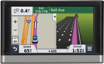
By and large, the world of modern navigators can be divided into two halves. The first is the products of the company Garmin, and the other includes all other navigators created by other manufacturers. According to many users, Garmin surpasses its competitors in terms of assortment, ease of use, thoughtfulness and quality of manufacture. The manufacturer equips the devices with its own operating system, which is correct for warranty. Simple models of Garmin car navigators, usually, are similar in function and differ from each other primarily in screen size: 3.5" at Garmin Nuvi 30 ; 4,3" from Garmin Nuvi 42 and 5" at Garmin Nuvi 50 . On the one hand, the map is better visible on the big screen, and on the other hand, the bulky navigator case worsens the visibility of the windscreen. For the review, we selected the most common option — Garmin Nuvi 42. The screen resolution of the Nuni 42 is standard 480x272. Routing by address search is easy, the only feature of the search is that small towns and villages need to be searched through the city search engine. When driving along a paved route, the 3D road interchange function works on some motorways. There is a visual and voice warning about the right lane before the interchange.
The built-in lithium-ion battery of Garmin devices, usually, holds a charge according to the 2 hours stated in the passport. |
 Price from 6 005 ₴
|
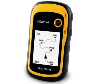
One of the most affordable models among tourist navigators. Thanks to its rounded shape and rubberized body, it is convenient to hold in your hand. The device can also be used when riding a bicycle / moto / ATV, if you purchase a separate holder for attaching a GPS navigator to the steering wheel. For rock climbers, there is a mount with a carabiner on the market. The operating time from two removable AA batteries is up to 25 hours, which greatly distinguishes a tourist navigator from a car one. Shockproof and waterproof housing will withstand any weather conditions while traveling. A monochrome display is already a rarity in modern gadgets, but it is on it that the image is best seen in bright sunlight. The control is carried out using rubberized side buttons and a joystick. eTgeh 10 has only 8 GB of built-in memory with base cards from all over the world. The possibility of downloading additional maps is not provided. According to user reviews, it is very easy to create routes and save waypoints, even if you are using such a device for the first time. The USB port provides the ability to connect to a computer to download geocaching caches (a special tourist game, the essence of which is to find caches hidden by other participants). To increase the accuracy of determining your location on the map, you can enable the definition of GPS and GLONASS satellites in the menu at the same time.In addition, eTgeh 10 has a compass, a calendar, a stopwatch and a travel computer that stores information about the speed and time of the completed or remaining route. As for similar models, we will highlight Garmin Dakota 10 and Garmin eTrex 20 , which boast colour touch displays and the ability to download additional maps. |
 |
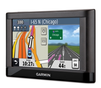
Navigator with a 5-inch touch screen and a resolution of 480x272. The device supports both the "car" landscape orientation of the screen and the "tourist" book orientation. However, a full battery charge is enough for 2.5 hours of battery life with the display always on, which means that first of all the model is designed for use in cars. The function of making a route by voice address search is implemented, which allows the driver not to take his hands off the steering wheel. The navigator is also equipped with a number of additional functions, such as voice prompts associated with visual landmarks ("Turn right behind the cathedral"), or information about nearby POIs (gas stations, cafes, hotels), but so far working only in Europe and America. The built-in Bluetooth module provides the ability to connect to a smartphone for hands-free communication. If you install a free branded Smartphone Link application on your phone at the same time, the functions of the navigator can be significantly expanded. The application uses the mobile Internet of the phone (GPRS) to download traffic information, the current weather forecast for the current location, search for parking places, etc. The built-in 2 GB memory is occupied by detailed maps of Ukraine from Navlux or Aeroscan and Russia from Navik, there is a micro SD slot for expansion with additional cards. Among similar models, we can distinguish Garmin Nuvi 3490LT and Garmin Nuvi 3597 . |
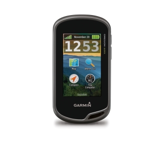 |
The latest model in our today's selection of the best GPS navigators, which is more similar in body shape to a tourist one. In fact, the device is universal, because functionality allows you to use it for sea and hiking trips, for hunting and fishing, for training on a bicycle and for auto navigation on highways. All models of the Oregon series see American (GPS) and Russian (GLONASS) satellites and are supplied complete with a carbine. The ending "t" in the name of the Oregon 600t/650t models indicates a complete set of topographic maps of Europe, and the models Garmin Oregon 650 and Garmin Oregon 650t additionally, there is a built-in camera with a flash. The 3-inch touchscreen (400x240) distinguishes the Oregon 600t from other tourist models. There are also side buttons here, but there are only two of them — on/off and assignable. Horizontal/landscape orientation of the screen is provided. For use in the car, there is an audio notification about turns when driving along the route, a 3D map mode, as well as the ability to work from a car cigarette lighter (cable is purchased separately). Users note that even when exposed to direct sunlight, information from the travel computer and data from the heart rate sensor are visible on the screen, which should interest runners. For cyclists, there is information from a sensor that tracks the speed of pedaling per minute. One battery charge lasts up to 16 hours. If this is usually a lot for athletes, then hunters and fishermen can still be recommended to take a set of spare batteries with them. The Oregon 600t is equipped with a barometric altimeter, a three-axis electronic compass, a calendar for hunting/fishing, a table of sunrises, sunsets, tides and special functions for geocaching. Supports wireless data transmission (waypoints, tracks, routes and geocaching caches) via Bluetooth. The microSD card slot makes it possible to install additional cards, for example, BirdsEye satellite images and detailed BlueChart g2 and Unity Navigator maps. |
Six modern devices that make life easier for the driver behind the wheel.
Overview of 5 good tape recorders designed for installation in 1 DIN sockets.
We have selected 5 headphones that can turn listening to music into a real pleasure.
Five interesting dvuhsimochnikov. Especially for those who are tired of carrying two phones for different numbers.
For this material, we have selected 5 excellent multifunctional tape recorders for installation in a 2 DIN socket.


Articles, reviews, useful tips
All materials
